Wormwood Scrubs to Greenford - London Canal Loop Part 3
Join us to continue our stroll along the Grand Union Canal in North West London. We’ll start where we left off in Part 2 and make our way west along the canal. This time the canal is a bit busier then last time with plenty of cyclists (one with a whistle) and electric scooters on the towpath and a good number of boats moving on the canal. As well as that there’s some interesting wildlife with a group of seagulls having a bath as well as the usual assortment of ducks and geese. In Willesden we some across a cut-off bridge with after some later digging turns out to the remains of an old Jetty from the early 1910s. While passing through an industrial estate full of warehouses and some on-location set vehicles we spot a view of the magnificent arch of Wembley Stadium in the distance before getting a slightly better view once we’ve crossed over the busy North Circular Road. From there we encounter a boat with a lovely traditional canal boat engine and then it’s onwards back towards habitation on the approach to Alperton Underground Station. Passing the station, and the nearby Sainsburys Supermarket where we stopped for a bit to get lunch, we come across a boat that seems somewhat adrift. Do we stop and help? No, we take the modern approach and send a tweet to the Canal and River Trust :p A little further on from this we end up sharing the path with one of the other footpaths I’d like to complete at some point, the Capital Ring. See below for a link to the info on that one. It’s not all that much further now until we come into Greenford and call and end to this part of the video, from where we’ll continue in the next part.
Subscribe and check out the playlist for future instalments as we carry on the walk along the Grand Union Canal and then later onto the River Thames. Includes SDH (Subtitles for the Deaf or Hard-of-Hearing) captions.
Interactive Route Map: https://www.mapchannels.com/videomap/map.htm?folder=29726&map=29726-london-canal-loop---part-3
Outtakes & Unused Footage: https://youtu.be/UZnAHAVWc1U
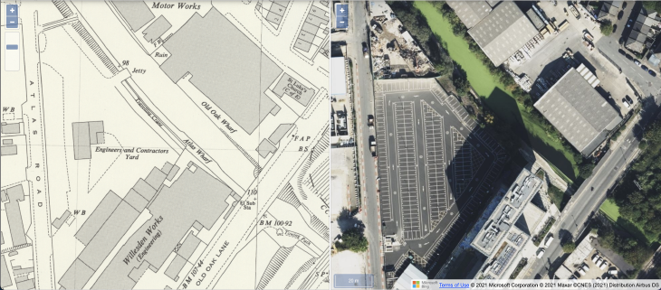
Atlas Wharf Jetty
 While investigating the “cut off bridge” found in this video Google Earth wasn’t of much help but the historical map side-by-side comparison tool from the Map Images collection of the National Library of Scotland really helped narrow down both the purpose and date of the structure.
By comparing the “OS London, 1:1,056, 1893-1895” and “OS 25 Inch, 1892-1914” maps it appears that the Jetty was constructed between these two maps being produced, between 1895 and 1914. This is making the assumption that the entire map would have been updated at the end of its publication but that’s probably not entirely true so if any more information comes to light I’ll update it here.
Useful Links
- Grand Union Canal (Paddington Arm) - https://canalrivertrust.org.uk/enjoy-the-waterways/canal-and-river-network/paddington-arm-grand-union-canal
- Geoff Marshall - https://www.youtube.com/user/geofftech2
- All The Stations - https://www.youtube.com/c/AllTheStations
- Tom Rolt: Narrow Boat (silent video) - https://youtu.be/yhbgBveNugI
- South West Rail Sidings - https://www.openrailwaymap.org/?style=electrified&lat=51.5294983136078&lon=-0.2474042773246765&zoom=18
- The Collective, Old Oak - https://www.thecollective.com/coliving/old-oak
- Atlas Wharf Jetty - https://maps.nls.uk/geo/explore/side-by-side/#zoom=19&lat=51.52953&lon=-0.25096&layers=170&right=ESRIWorld
- Grand Junction Arms - https://www.grandjunctionarmsnw10.co.uk/
- Royal Mail - https://www.royalmail.com/
- Berkley Homes, Grand Union - http://grandunion.uk/
- Bakkavor Meals, Park Royal Factory - https://www.bakkavor.com/
- Capital Ring Walk - https://tfl.gov.uk/modes/walking/capital-ring
- London LOOP Walk - https://tfl.gov.uk/modes/walking/loop-walk
- Horsenden Hill Conservation Area - https://www.ealing.gov.uk/info/201136/parks_in_the_borough/663/greenford_parks/4
- Tir Chonaill Gaels Club - https://www.tirchonaillgaels.co.uk/
- The Black Horse, Greenford - https://www.blackhorsegreenford.co.uk/
Credits
- Middlesex Coat of Arms by Fenn-O-maniC, CC BY-SA 4.0 via Wikimedia Commons https://creativecommons.org/licenses/by-sa/4.0
- Record Scratch by SkyernAklea on FreeSound.org
- Music: Canals by Joakim Karud - https://www.youtube.com/c/JoakimKarud
- Map © Mapbox - https://www.mapbox.com/about/maps/
- Map Data © OpenStreetMap and contributors - http://www.openstreetmap.org/about/
- Map Compass by FreePik.com
- Vector Grunge Background by sergey_kandakov on FreePik.com
- 4K Icon by Vecteezy.com
Mistakes
- None so far
Let me know if you find any :)